Robbin B. Sotir & Associates, Inc.
RETROFIT OPPORTUNITIES FOR URBAN WATERS USING SOIL BIOENGINEERING
Soil bioengineering techniques offer a natural way to repair streambank erosion while benefiting the environment
By Robin Sotir
Robbin B. Sotir & Associates, Inc., Marietta, Georgia
Abstract
In response to increasing environmental concerns, streambank protection efforts are expected to address the results of nonpoint source impacts within developed urban watersheds. Retrofit opportunities to restore incised and enlarged channels as well as those that have been relocated and/or straightened are discussion in this paper. Soil bioengineering systems that utilize woody vegetation can provide sound streambank protection while maximizing ecological and water quality benefits in urban waters.
Soil bioengineering retrofits have been used to meet specific objectives, such as flood control, stormwater management, bank stabilization, aesthetics and habitat enhancement. Case studies from different parts of the country are presented to illustrate the use of this technology. Information is presented for evaluating alternative soil bioengineering streambank protection measures and selecting those that best achieve the desired goals. These retrofit procedures have been used on several projects where geotechnical hydrological/hydraulic as well as environmental objectives needed to be met. The projects include a flood control stream in an urban linear park in Charlotte, North Carolina, a relocated stream in Portland, Oregon, a flood control channel through a residential neighborhood in Houston, Texas and a new erosion and flood control stream restoration project underway in a residential neighborhood in Wilmington, North Carolina.
Introduction
The results of nonpoint source impacts on streams and the adjacent lands through which they flow within developed urban watersheds has become increasingly alarming in many metropolitan areas throughout North America. Many streams both large and small experience channel incision and widening especially where streams have been relocated and/or straightened. In addition to direct relocation and straightening efforts to manipulate urban waterways, uncontrolled stormwater runoff is causing the same enlargement results in increased cross-sectional areas. Compounding this, except for the construction phase the stormwater runoff carries far less sediment. Couple this with increased frequency and magnitude of these flows and their associated velocities causes extreme erosion damage to channel beds and banks in urban areas, resulting in the loss of valuable land.
Some of the most common urban stream erosional conditions were developed for several reasons such as: straightening and shortening of channels in developing urban areas is often done to increase and consolidate developable land for sale, bypass lakes or public parklands to reduce sediment deposition and to make construction easier by eliminating channels in prime construction areas.
"Stream power is proportional to the product of discharge and slope. Both variables are increased when streams are straightened during development and subjected to increased discharges. Stormwater detention is a relatively recent concept, and most of the subdivisions and commercial sites developed during the 1960's and 1970's have no stormwater detention facilities." (Nunnally, 1997)
It is thought that such actions simplify, speed up, and increase opportunities for resale and profits for industrial, commercial and residential property. Considerations beyond traditional land "repackaging" for convenience and short term resale value not only appear to ignore the inevitable initial sediment transport which occurs during the construction phase, and long term channel stabilization problems, they also loose water quality, aesthetic values and a host of other environmental benefits including aquatic and terrestrial habitat. The retrofit recovery opportunity of many of these through the use of soil bioengineering is discussed in this paper using case studies.
Geotechnical, Hydraulic and Hydrologic Benefits of Soil Bioengineering
Soil bioengineering methods offer a broad range of mechanical benefits when installed as retrofits to damaged urban stream systems. See Table 1 - Soil Bioengineering System Geotechnical and Hydraulic Goals and Benefits. Geotechnically they are able to offer immediate soil reinforcement up to a depth of twelve feet (12'). The use of brushlayers with natural or synthetic geogrids, is especially useful where space is constrained, as these methods may be constructed very steeply, 1H to 1V and in some cases as steep as .25H to 1V. The installed vegetation offers many added values in that hydrologically the embedded branches serve as horizontal drains converting parallel seepage flow to vertical flow. This improves the factor of safety thus offering improved overall slope stability. Surface protection and reinforcement is further increased when live branches develop roots and top growth. The roots tend to consolidate the soil particles by reinforcing the soil mantle thus reducing the possibility of slips and displacements. The top leaf and branch growth provides direct bank protection as well as reducing the velocities and redirects the flow away from the bank.
Table 1
Goals and Benefits |
Soil Bioengineering Methods |
|||||||
*Live Stakes |
Live Fascine |
Live Siltation Construction |
Branch-packing |
Brush-matress |
Live Cribwalls |
Vegetated Geogrid |
Live Boom(s) |
|
Geo-Technical |
fair |
good to very good |
n/a |
good |
n/a |
excellent |
excellent |
n/a |
Hydraulic |
fair to good |
good to very good |
very good to excellent |
excellent |
very good |
good to very good |
good |
fair to good |
Environmental Benefits of Soil Bioengineering
Soil bioengineering offers a wide variety of environmentally sound retrofit opportunities for urban waterways. Some of the main benefits available for different methods have been summarized in Table 2 - Environmental Benefits of Soil Bioengineering Streambank Restoration Systems. This may serve as a starting point and be a useful guideline in the selection of specific vegetative methods that can be incorporated into streambank designs to enhance specific desirable environmental benefits. "Soil bioengineering systems that provide overhanging cover through live siltation construction or the scour hole procedure by live booms (dikes composed of woody vegetation and soil) on stream systems make them excellent choices as part of a bank protection system on streams where shade and overhanging cover or pool habitat is desirable." (Sotir 1997). The habitat for mammals and birds will improve over time in such areas as nesting, migration and cover.
Table 2
Goals and Benefits |
Soil Bioengineering Methods |
||||||
Vegetated Geogrid |
Live Cribwalls |
Live Boom(s) |
Live Siltation Construction |
Brush-matress |
Live Fascine |
*Live Stakes |
|
Shade and Overhang Cover |
excellent |
excellent |
very good |
excellent |
good to very good |
good |
fair to good |
Create or Preserve Scour Holes |
good |
very good |
excellent |
n/a |
n/a |
n/a |
n/a |
Riparian Habitat |
fair to good |
fair to good |
n/a |
very good to excellent |
excellent |
good to very good |
fair to good |
*Recreation |
very good |
very good |
n/a | good to very good |
good to very good |
good | ,
fair |
"In addition to the selection and orientation of methods, woody vegetation species selected for inclusion in soil bioengineering systems can also have a significant effect on the habitat benefits. Various species of willow are the most common woody plants used in soil bioengineering. While willow has excellent rooting capabilities and can provide good overhanging cover and shade for streams, good nesting habitat for some species of birds and some cover for mammals, other species offer better food sources for land animals to accomplish specific habitat objectives. Such plants are incorporated into soil bioengineering designs to provide special habitat benefits for target species." (Sotir 1997).
Johnson Creek Relocation and Restoration
Johnson Creek is located in a highly urbanized area of Portland, Oregon metropolitan area, with land uses ranging from heavy industry to low-density residential. It is a third-order stream with a 100-year discharge at the project site of about 4,400 cfs. Flood control efforts during the 1930's enlarged, but did not straighten the stream. A survey of Johnson Creek revealed that with few exceptions, streambanks are stable, heavily vegetated, and provide excellent riparian habitat and overhanging cover for the stream.
The Oregon Department of Transportation (ODOT) proposed relocating a section of Johnson Creek in the Town of Milwaukee, Oregon for bridge and highway construction. See Figure 1. The relocated section would be about twenty percent (20%) shorter than the existing channel with a commensurate increase in gradient. A local committee, created because of concerns over degraded water quality and aquatic habitat and an interest in restoring an anadromous fishery, were worried about potential impacts of the stream relocation. The relocated stream reach is in a highly visible location, and the riprap channel proposed by ODOT would present a stark, sterile appearance and cause further loss of habitat and aesthetic value.
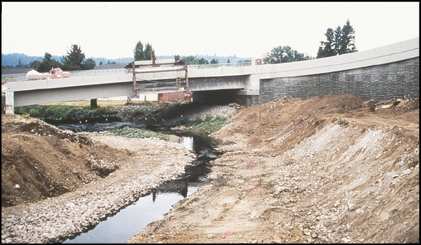
Figure 1
Johnson Creek after realignment activities
Robbin B. Sotir & Associates, Inc. (RBSA) was retained by ODOT to evaluate the proposed channel design for stability and for potential impacts to aquatic and riparian ecosystems and to modify the design as needed to address the concerns voiced by the Johnson Creek Corridor Committee. The review determined that the proposed trapezoidal channel cross-section shape and gradient were too uniform and that the floodplain berms were too high. RBSA recommended changes to the channel to improve stability, water quality, and habitat value (Sotir and Nunnally, 1995). The channel cross-section was altered by lowering flood plain berms, incorporating a sub-channel sized to convey bankfull flows, and constructing a low flow channel to concentrate flows during the summer months. A pool-riffle sequence was created by widening the sub-channel and raising the invert by one foot (1') in cross-over reaches and by lowering the invert by one foot (1') in outside meander sections.
Robbin B. Sotir & Associates, Inc. (RBSA) was retained by ODOT to evaluate the proposed channel design for stability and for potential impacts to aquatic and riparian ecosystems and to modify the design as needed to address the concerns voiced by the Johnson Creek Corridor Committee. The review determined that the proposed trapezoidal channel cross-section shape and gradient were too uniform and that the floodplain berms were too high. RBSA recommended changes to the channel to improve stability, water quality, and habitat value (Sotir and Nunnally, 1995). The channel cross-section was altered by lowering flood plain berms, incorporating a sub-channel sized to convey bankfull flows, and constructing a low flow channel to concentrate flows during the summer months. A pool-riffle sequence was created by widening the sub-channel and raising the invert by one foot (1') in cross-over reaches and by lowering the invert by one foot (1') in outside meander sections.
The soil bioengineering systems were installed in the winter of 1993 and spring of 1994. During the early spring and before the plants had established growth, the site experienced a 1,750 cfs flood with mean velocities between six feet and seven feet (6' - 7') per second and maximum velocities established to be in excess of ten feet (10') per second. The soil bioengineering systems were secure, and by the end of the growing season they were providing excellent bank protection and habitat benefits. See Figure 2. The project continued formal monitoring until the winter of 1997 by the Beak Consultants and RBSA for vegetation cover and species as well as bird and waterfowl species and activities.
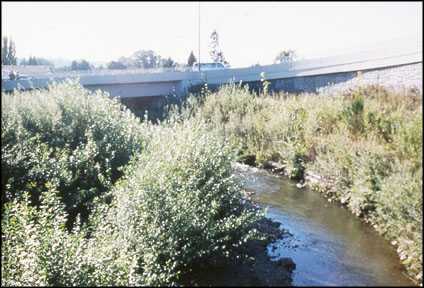
Figure 2
Johnson Creek four years after construction
Buffalo Bayou Bank Stabilization and Aesthetic Improvement
The only stream of any size in Houston, Texas that has not been channelized for flood controls is Buffalo Bayou upstream of Sheperd Drive. The watershed of Buffalo Bayou is almost totally urbanized and Addicks Reservoir was constructed upstream to alleviate flooding. The combination of natural flooding and operation of the flood gates at Addicks results in abrupt rise and fall of the water level in the Bayou coupled with prolonged periods of both high and low water levels. These hydrologic conditions, combined with sandy and silty soils with little cohesion, have resulted in widespread erosion and large streambank failures.
Several soil bioengineering streambank protection projects were built on Buffalo Bayou between 1990 and 1995 (Nunnally and Sotir, 1994; Gray and Sotir, 1996). The 1990 sites survived one of the largest floods of record in 1992 without damage. The installation described here was constructed in 1992 - 93 following that flood.
The project site is two hundred and eighty feet (280') long and its height varies from twenty-five feet to thirty-five feet (25' - 35') and is located in an outside bend. Due to the receding bank, over twenty feet (20') of land had been lost. See Figure 3. The bank recession was caused by a combination of mass slope failure and streambank erosion. The instability of the oversteepened slope was aggravated by the presence of fine sand and seepage between two hundred and two thousand (200 - 2,000) gallons per day of water seeping from the bank face. While the main goal for this project was to stabilize the bank and stop the erosion, the client was also interested in the restoration of the riparian zone, aesthetic improvements and the ability to maintain a view to the Bayou.
To achieve long-term bank stabilization, it was necessary to initially install a foundation of wrapped concrete rubble that was installed in a seven-foot (7') deep toe trench. A fill slope with a grade of 0.5 H:1V was reconstructed above this foundation. The fill was constructed in two-foot (2') lifts wrapped with a geogrid. Thick layers of brush long enough to extend from the undisturbed soil at the back of the bench and protrude several feet beyond the slope face were placed between each wrapped soil layer. The overall construction height was forty-two feet (42'). The upper half of the bank was steepened to 0.25H:1V. Continued seepage would have substantially reduced the factor of safety, it was therefore necessary to install additional drainage to remove the water. Drainage was accomplished by using vertical chimney drain construction that collects the water and conducts it into a gravel trench drain that, in turn, discharged into the Bayou.
The site has experienced several floods and has remained stable since construction. The soil bioengineering installation is developing into a dense riparian buffer as native and naturalized species continue to invade the site. See Figure 4.
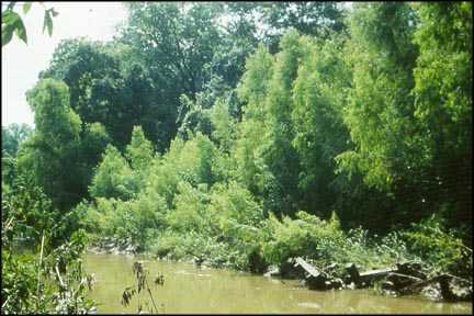
Figure 4
Buffalo Bayou five years after construction
Little Sugar Creek Stabilization, Habitat Restoration & Flood Control
This four thousand six hundred and fifty-foot (4,650') section of Little Sugar Creek is in the Huntington Farms Park area in the City of Charlotte, North Carolina. This linear park is located along the creek in a predominately residential neighborhood. It is owned by the City of Charlotte and maintained by Mecklenburg County Storm Water Services.
Like most other streams in Charlotte, Little Sugar Creek was channelized to improve drainage in the early 1900's, and it has been dredged and snagged several times since then, often leaving the channel without any vegetative cover on its banks. The stream drains much of eastern and central Charlotte, and the watershed is highly urbanized. The frequent flooding and high peak discharges caused significant bank erosion and channel enlargement. The immediate area had also been used as a constructed landfill in the past. At several locations, bank erosion had uncovered construction debris burial sites containing tree trunks, waste construction materials, and miscellaneous organics. See Figure 5.
An interdisciplinary team including hydrology, surveying, and geotechnical expertise, aquatic science, fluvial geomorphology, and soil bioengineering was assembled to assess the site and to develop solutions to reach the multi-objective restoration and stabilization project goals included: bank stability, erosion protection, aquatic habitat enhancement, water quality and aesthetic improvement, community education and economic savings.
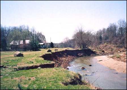
Figure 5
Little Sugar Creek erosion failures before construction
Design studies were initiated in April, 1996 producing conceptual alternative designs with costing information. Initially, erosional bank failures along the creek were evaluated, typed, and matched with appropriate solutions. From this, final plan and specification documents were prepared. Riprap rock was reduced along the toe and in some cases completely eliminated. This dramatically reduced the project costs. Construction was completed in March, 1997.
Soil bioengineering methods such as live fascines and brushmattresses were employed in different configurations along the banks. The project received an early flood event prior to construction completion. Later, four (4) months after installation, Little Sugar Creek received a flood that exceeded the 100-year event. The project sustained no damage. While this project is a very new installation, to date, it has become well vegetated, offering enhanced riparian benefits, overhanging cover, aesthetic improvements and bank stability. Banks appear stable and are aesthetically pleasing. See Figure 6. The instream habitat structures (current deflectors and rocks) have also been performing well, having produced a variety of scour hole cover and resting areas for fish. The project will continue to be monitored over the next few years to track its performance.
Long Leaf Hills/Hewlett's Creek Stabilization, Aesthetic and Habitat Enhancement
This stretch of Long Leaf Creek is located in a residential neighborhood known as Long Leaf Hills Subdivision. The project reach starts upstream from Shipyard Boulevard and ends at the confluence of Hewlett's Creek. Streams in the Wilmington area, including Long Leaf Creek, have been altered by accepting increased stormwater runoff due to urbanization of the watershed. The stream floods frequently in the lower section. This increased flooding and high peak discharges have caused significant bank erosion and channel enlargement. The channel has become both deeper and wider. Compounding the increased stormwater problem is bank seepage and uncontrolled overbank runoff, which also contributes to bank failure. Finally, the creek has been used as a dump-site for organic garden debris which kills the bank vegetation and is exasperating erosional failures. These mechanical, hydrologic, and hydraulic problems have caused degradation of the aesthetic and riparian corridor values in the creek. Public meetings illuminated the desirable past conditions of the creek, the concerns of the existing conditions and their interest for stabilization and restoration in terms of how they wanted to use and enjoy their creek in the future. See Figures 7 and 8.
Kimley-Horn & Associates, Inc., the prime consultant in Wilmington, NC, and Robbin B. Sotir & Associates, Inc., prepared six (6) conceptual alternatives which included a simple intermediate action for clean up and stabilization, grass, riprap rock and concrete liners, box convert, and soil bioremediation. They were matched up with eleven (11) critical issues that were assessed with each alternative. See Table 3 - Long Leaf Hills/Hewlett Creek Critical Issues.
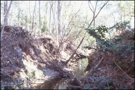
Figure 7
Long Leaf Hills/Hewlett Creek - Illustrate failure conditions along the creek
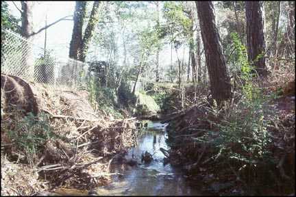
Figure 8
Long Leaf Hills/Hewlett Creek - Illustrate failure conditions along the creek
Table 3
Critical Issues ALT.#1 Intermediate Action ALT.#2 3:1 Side Slopes Grass Lining ALT.#3 2:1 Side Slopes Riprap Rock ALT.#4 2:1 Side Slopes Concrete Lining ALT.#5 Reinforced Box Convert ALT.#6 Soil Bioengineering Stop Erosion & Stabilize Banks * * * * Clean Out Trash & Debris * * * * * * Remove Fallen Trees * * * * * * Safer & Healthier Areas * * * * * Timely Project Completion * * * * * * Environmental Improvement * * * Aesthetically Enhancing * n/a * Meets Bank Stability & Hydraulic Efficiency * * n/a * Minimize Property Loss * * * Financial Feasibilty * * * * * *
Adapted from: Kimley-Horn & Associates, Inc. 1997
n/a
*
*
Control Flooding
Soil bioengineering that is based on sound engineering practice and ecological principles was selected by the neighborhood and the client as it fulfilled all the criteria. The project is proceeding into the final design stages. Construction is scheduled to start in the fall of 1998 and is expected to be completed by late winter of 1999. Monitoring will be performed after construction to evaluate the stabilization and restoration development of Long Leaf Hills/Hewlett Creek.
Summary
Urban water restoration and stabilization projects involve multiple objectives. In addition to controlling erosion in a cost-effective manner, on these retrofits we are increasingly concerned with water quality, habitat, aesthetics, recreational use and other environmental objectives. Soil bioengineering designs that employ woody vegetation meet these environmental objections better than other types of streambank protection, especially when integrated with other technology. Maximum retrofit opportunity benefits are derived by choosing soil bioengineering, which provides a value-added sustainable system. The successful retrofit applications of soil bioengineering on urban waters discussed in this paper indicate that this approach to stabilization and restoration is successful.
References
Gray, D.H. and Sotir, R.B., 1996. Biotechnical Soil Bioengineering Slope Stabilization: A Practical Guide for Erosion Control. John Wiley & Sons, New York, NY.
Gray, D.H. and Sotir, R.B., 1995. Biotechnical Stabilization of Steepened Slopes. Transportation Research Board, NAS-NRC.
Robbin B. Sotir & Associates, Inc., Reconnaissance and Conceptual Design - Long Leaf Drainage Improvements Project, Wilmington, NC. Proposed Soil Bioengineering Stabilization and Restoration Report, Sotir, R.B., 1997.
Nunnally, N.R. and Sotir, R.B., 1997. Criteria for Selection and Placement of Woody Vegetation in Stabilization Protection, Oxford, MS May pp. 8166-821.
Sotir, R.B., 1997. Urban Watershed Restoration, National Urban Forestry Conference, Atlanta, GA. Sept. 1997.
Sotir, R.B., 1997. Designing Soil Bioengineering Streambank Protection for Multiple Objectives. Proceedings, Conference on Management of Landscape Disturbed by Channel Incision Stabilization Rehabilitation Restoration, Oxford, MS, May, pp. 325-350.
Sotir, R.B. and Nunnally, N.R., 1995. Soil Bioengineering for Stream Restoration. Water Resources Engineering, Vol, I: 795-799.
Tacoma Street Interchange Soil Bioengineering Project - Monitoring and Evaluation of Stability and Habitat - Fall 1996. Seasonal Monitoring Report Prepared for Oregon Department of Transportation. Prepared by: Beak Consultants, Inc. and Robbin B. Sotir & Associates, Inc.
USDA/NRCS, Chapter 16: 1997 Streambank and Shoreline Protection - Engineering Field Handbook.
USDA/NRCS, Chapter 18: 1992 Soil Bioengineering for Upland Slope Protection and Erosion Reduction - Engineering Field Handbook.
3221 Stoney Acres Drive
Kennesaw, Georgia 30152
Phone: 770-424-0719
sotir@sotir.com
©2020 Robbin B. Sotir & Asociates, Inc.